EUDR software for geolocation data and evidence
The EU Deforestation Regulation requires geolocation for every plot of production and a submitted due diligence statement. Our platform collects that data from your suppliers, validates it automatically and keeps the evidence in a form that still holds up five years later.
The effort is not in the submission
Filing the statement is tedious but solvable. The bottleneck sits upstream: collecting and validating plot data from suppliers who have no interest in using software.
15 to 30 minutes per supplier and plot
That is what manual handling costs, including chasing, format fixes and plausibility checks. With 150 suppliers that is several person-weeks — every year again.
Errors surface at submission time
Self-intersecting polygons, stated areas off by a factor of 100, coordinates in the wrong reference system, points outside the declared country of production. Collected by email and spreadsheet, these are found late or never.
A folder is not evidence
Evidence must be kept for five years and produced on request. A file share where anything can be changed afterwards proves little when it matters.
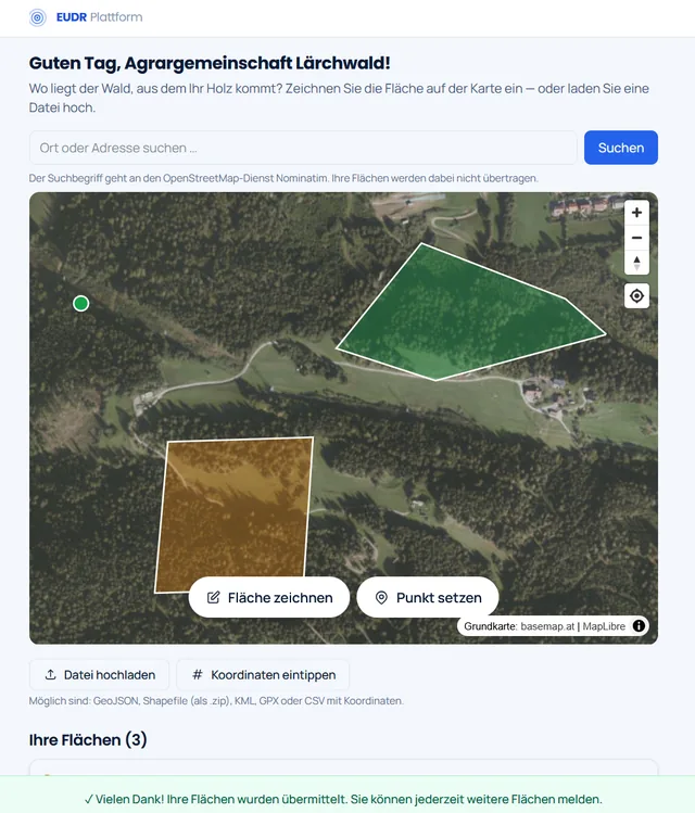
What your supplier sees
One click on the link and the forest owner is in — no account, no password, no jargon. They see their own name, current aerial imagery and two buttons.
- Draw a plot or drop a point — that is the whole decision.
- Anyone who already has the data uploads it: GeoJSON, Shapefile, KML, GPX or CSV.
- Green and amber are the validation result. The supplier sees it before confirming, and corrects it themselves.
And this is what you see
Every delivery with its evidence, and in the column beside it what is missing. Anyone about to close a gap first sees which one.
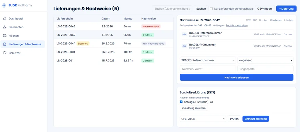
- Red means no inbound evidence is on file for that delivery.
- Own timber is flagged and needs none. The rule layer decides that, not the user.
- Reference and verification numbers sit with the delivery, along with counterparty and retention date. The due diligence statement is built from these.
Every plot is checked before it reaches a statement
Geometry, area, location within the country of production, forest cover on the cut-off date. The result sits on the plot itself as a traffic light, not in a log nobody reads.
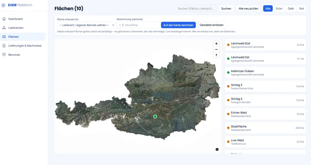
- Green means nothing was found. Amber means look at it before submitting.
- The area is shown on every plot. Below four hectares a point is enough; above it the regulation requires a polygon.
- "Re-check all" repeats the validation across the whole portfolio, for instance when a risk classification changes.
What the platform does
Seven building blocks covering the path from the first supplier request to a tamper-evident archive.
Collect geolocation without an account for the supplier
Your supplier receives a personalised, signed, time-limited link. They open it, see a map with current aerial imagery and draw their plot or upload an existing file: GeoJSON, KML, GPX, Shapefile or WKT. No registration, no password, no jargon.
Validate automatically, with a traffic light
Every incoming plot runs through the check chain: valid and non-self-intersecting geometry, plausible area, location inside the declared country of production, forest cover at the 31 December 2020 cut-off and loss since. The result is green, amber or red — with a plain explanation of what to do.
Corrections happen where the error originates
The supplier sees the feedback in the portal before confirming. The correction loop moves off your desk and back to the source.
Track evidence and expose gaps
Incoming and outgoing reference and verification numbers are recorded per consignment, individually or by CSV import. The system flags every consignment without evidence. Special cases such as wood from your own forest are supported and exported with a stated reason.
Prepare and hand over the statement
The due diligence statement is assembled from validated data. The form shows exactly the fields mandatory for the given profile. The connection to the EU information system is built and tested against the acceptance environment of the European Commission: connection, submission, retrieval of the reference number, error handling, amendment and retraction all run through. A standards-compliant GeoJSON export for manual upload is available as an alternative.
Archive in a tamper-evident way
Every action lands in a log where each entry carries the hash of its predecessor. The archive export is a ZIP with all data, a manifest, every checksum and an accompanying verification script: an auditor can confirm five years from now, without our software, that nothing was altered.
The legal position is configuration, not program code
Roles, mandatory fields per role and country risk, the polygon threshold, valid evidence types, retention periods — all of it is declarative configuration. When the interpretation changes, a file changes. No release, no waiting for a vendor.
Who we built this for
Sawmills and traders buying standing timber
Buying timber on the stump means you harvest and you place on the market. The full due diligence statement with plot geolocation is yours to file, not the forest owner's.
Forest owner associations, cooperatives and forestry groups
Selling in your own name makes you the operator, and the timber volumes of your members may be bundled into a single due diligence statement. Acting only as an authorised representative means one separate statement per member. Both routes are provided for, and the workload differs sharply.
Forestry operations that harvest themselves
Own timber counts like a standing purchase: whoever harvests places on the market and carries the full information duty, including geolocation for every plot of production.
What the platform is not
- Not legal advice. The rules layer models the regulation; responsibility for the statement stays with the operator.
- Not a replacement for registering in the EU information system. The operator does that once; we have documented the path and support it.
- Not software your suppliers must install. If a forest owner had to install an app, we would have moved the problem rather than solved it.
Frequently asked questions
When does the EUDR apply?
From 30 December 2026 for medium and large companies and for micro and small companies in the timber sector. From 30 June 2027 for the remaining micro and small companies. From the cut-off date, covered goods without a submitted statement cannot be placed on the market.
We hear the filing will be simple or free for almost everyone. Does that cover us?
Simplifications and state-provided tools address producers, meaning the forest owner selling their timber, and they concern the simplified statement under Art. 4a. If you buy standing timber, market in your own name or sit above the SME threshold, you are an operator and owe the full due diligence statement with plot geolocation for every consignment. That is a different procedure, and the producer simplification does not extend to it. The test is simple: do you harvest? Whoever harvests places on the market.
Who is the operator when roundwood is bought — the forest owner or the sawmill?
It depends on who harvests. If the mill buys finished roundwood, the forest owner harvested and placed it on the market. If the mill buys standing timber and harvests itself, the mill is the operator. The same rule applies to wood from your own forest.
Do we need a polygon for every plot?
A polygon is mandatory from a plot size of four hectares; below that a single point is sufficient. Either way, WGS 84 (EPSG:4326) with at least six decimal places applies.
Our country is low risk — is that not enough?
The classification removes risk assessment and risk mitigation under Articles 10 and 11. It does not remove the Article 9 information including geolocation, and it does not remove the statement itself. As soon as goods from a higher risk country are mixed in, the full procedure applies again.
Do our suppliers have to create an account?
No. The supplier opens a personalised link, draws the plot or uploads a file, and confirms. Issuing a new link invalidates the old one if someone misplaces theirs.
Can we submit without using the machine interface?
Yes. The platform produces a standards-compliant GeoJSON export for manual upload in the EU information system. That route works independently of any interface and is often the simpler one for operators filing few statements per year.
From how many suppliers does this pay off?
Work it out on your own numbers: suppliers owing plot data, times plots, times 20 minutes. If that comes to less than one working week per year, skip the purchase — a careful spreadsheet will do. From roughly twenty suppliers who actually have to provide plots, the calculation tips.
What happens when the legal position changes?
Everything that depends on interpreting the regulation is declarative configuration: roles, mandatory fields per role and country risk, the polygon threshold, valid evidence types, retention periods. A change is an edited file and a restart — not a software release and not a wait for a vendor.
Where does our data live?
The platform runs as a separate instance per company — in your own data centre or with a European host, as you prefer. Plot data is personal data; the supplier portal states openly who processes it, for what purpose, for how long and who has access.
We are not the slow part
Supplier response time sets the schedule, not the software. Starting in November leaves no margin. We will show you the platform on your own data: clarify whether you are covered, invite suppliers, have the first plots validated.